Aloha! Welcome to Papahānaumokuākea Marine National Monument
– where nature and culture are one
The name Papahānaumokuākea commemorates the union of two Hawaiian ancestors – Papahānaumoku and Wākea – who gave rise to the Hawaiian Archipelago, the taro plant, and the Hawaiian people.
Vision
To forever protect and perpetuate ecosystem health and diversity and Native Hawaiian cultural significance of Papahānaumokuākea.
Mission
Papahānaumokuākea Marine National Monument is the largest contiguous fully protected conservation area under the U.S. flag, and one of the largest marine conservation areas in the world. It encompasses 139,797 square miles of the Pacific Ocean (362,073 square kilometers) — an area larger than all the country’s national parks combined. (See map)
The Northwestern Hawaiian Islands Marine National Monument was established by Presidential Proclamation 8031 on June 15, 2006 under the authority of the Antiquities Act (16 U.S.C. 431-433). It was expressly created to protect an exceptional array of natural and cultural resources. A year later, it was given its Hawaiian name, Papahānaumokuākea. (Learn more about the meaning, pronunciation and significance of our name here.)
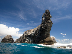
Spire-like Mokumanamana is one of the many dramatic features in the Monument. Credit: Wayne Levin
The extensive coral reefs found in Papahānaumokuākea — truly the rainforests of the sea — are home to over 7,000 marine species, one quarter of which are found only in the Hawaiian Archipelago. Many of the islands and shallow water environments are important habitats for rare species such as the threatened green turtle and the endangered Hawaiian monk seal, as well as the 14 million seabirds representing 22 species that breed and nest there. Land areas also provide a home for four species of bird found nowhere else in the world, including the world’s most endangered duck, the Laysan duck.
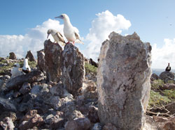
Boobies perch atop ceremonial shrines in the Monument. Credit: Kaleomanuiwa Wong
Papahānaumokuākea is of great importance to Native Hawaiians, with significant cultural sites found on the islands of Nihoa and Mokumanamana, both of which are on the National and State Register for Historic Places. Mokumanamana has the highest density of sacred sites in the Hawaiian Archipelago and has spiritual significance in Hawaiian cosmology (learn more). Papahānaumokuākea is also home to a variety of post-Western-contact historic resources, such as those associated with the Battle of Midway and 19th century commercial whaling (learn more).
World Heritage
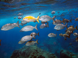
Sealife abounds on the pristine reefs in the Monument. Credit: Kaleomanuiwa Wong
On July 30, 2010, Papahānaumokuākea was inscribed as a mixed (natural and cultural) World Heritage Site by the delegates to the United Nations Educational, Scientific and Cultural Organization’s (UNESCO) 34th World Heritage Convention in Brasilia Brazil. It is the first mixed UNESCO World Heritage Site in the United States and the second World Heritage Site in Hawaiʻi (learn more).
Various protection efforts in the region have been enacted over the century, beginning in 1903 when President Theodore Roosevelt sent in the U.S. Marines to stop the slaughter of seabirds for feathers and eggs at Midway Atoll. Over the next 100 years, six U.S. Presidents and one Hawai’i Governor afforded the region increasing protection (learn more).
The Monument has a unique co-management structure, with three Co-Trustees and seven Co-managing agencies (learn more). These groups work together to achieve the Monument’s vision and mission.
Источник
Папаханаумокуакеа

Папаханаумокуакеа – морской заповедник в США, в состав которого входят несколько островов и атоллов Северо-Западных Гавайев. Одна из крупнейших в мире природоохранная территория и наибольшая из морских охраняемых территорий. Создана для сбережения местной экосистемы.
Заповедник Папаханаумокуакеа был создан в середине июня 2006 г. указом президента Дж. Буша-младшего. Тогда размер памятника был меньше: 360 тыс. кв. км. Название Папаханаумокуакеа территория получила лишь на следующий год. Название состоит из двух частей: Папаханаумоку – имя богини-созидательницы, своего рода Мать-Земля, одна из главных божеств гавайского пантеона. А Укакеа – ее муж, Отец-Небо, олицетворение мужского божественного начала.
В 2010 г. заповедник был признан объектом Всемирного наследия, а спустя 10 лет с момента образования, в августе 2016 г., его территория была расширена до границ, в каких он находится и сейчас, теперь его площадь составляет более 1,5 млн кв. км. Заповедник включает почти 70% всех коралловых рифов Соединенных Штатов. На островах Неккер и Нихоа археологами найдены артефакты, относящиеся к поселениям доевропейского периода.

Фауна Папаханаумокуакеа составляет более 7 тыс видов, из них около 25% являются эндемичными. При этом исследования морских глубин продолжаются – и список их обитателей пополняется. Например, в 2010 г. подводная экспедиция вблизи берегов атолла Куре обнаружила новые виды кораллов и других морских обитателей. Из редких животных, обитающих здесь, в первую очередь следует назвать тех, кто внесен в Красную книгу:
• гавайские тюлени-монахи; • зеленые морские (или суповые) черепахи; • биссы, или настоящие каретты – еще один вид морских черепах.
На многочисленных островках гнездятся птицы:
• темноспинные, или лайсанские альбатросы; • лайсанские вьюрковые цветочницы; • лайсанские кряквы – этот маленький (чуть более 4 кв. км) островок богат эндемичными видами; • телеспизы.
В прибрежных водах можно увидеть синего кита, несколько видов акул и сотни видов мелких рыбешек.

Как посетить национальный памятник?
Лучше всего приобрести экскурсию на посещение заповедника Папаханаумокуакеа. Однако те туристы, которые хотят посетить его самостоятельно, тоже могут сделать это: в Гонолулу можно арендовать частную яхту.
Источник
Национальный морской парк «Папаханаумокуакеа»
Papahānaumokuākea is a vast and isolated linear cluster of small, low lying islands and atolls, with their surrounding ocean, roughly 250 km to the northwest of the main Hawaiian Archipelago and extending over some 1931 km. The area has deep cosmological and traditional significance for living Native Hawaiian culture, as an ancestral environment, as an embodiment of the Hawaiian concept of kinship between people and the natural world, and as the place where it is believed that life originates and to where the spirits return after death. On two of the islands, Nihoa and Makumanamana, there are archaeological remains relating to pre-European settlement and use. Much of the monument is made up of pelagic and deepwater habitats, with notable features such as seamounts and submerged banks, extensive coral reefs and lagoons. It is one of the largest marine protected areas (MPAs) in the world.
Description is available under license CC-BY-SA IGO 3.0
Papahānaumokuākea
Papahānaumokuākea est le nom d’un vaste groupe linéaire et isolé de petites îles et atolls à faible altitude (océan autour compris) situées à près de 250 km au nord-ouest du principal archipel hawaiien et qui s’étendent sur environ 1931 km. Le site possède une signification cosmologique pour les natifs hawaiiens, en tant qu’environnement ancestral, incarnation du concept de parenté entre les hommes et le monde naturel, berceau de la vie et terre d’accueil des esprits après la mort. Sur deux des îles, Nihoa et Makumanamana, on trouve des vestiges archéologiques relatifs au peuplement et à l’occupation des sols à l’époque pré-européenne. C’est aussi une zone d’habitats pélagiques et d’eaux profondes avec des caractéristiques remarquables telles que des monts sous-marins et des bancs submergés, de vastes récifs coralliens et des lagons. Il s’agit de l’une des aires marines protégées les plus vastes du monde.
Description is available under license CC-BY-SA IGO 3.0
باباهاناوْموكواكيا، في هاواي
إن باباهاناوْموكواكيا هو اسم لمجموعة من الجزر الصغيرة والجزر المرجانية ذات الارتفاع المنخفض تمتد على مساحة 250 كيلومتراً تقريباً شمال غرب الأرخبيل الرئيسي في هاواي. ويتسم الموقع بأهمية كونية بالنسبة إلى أبناء هاواي، إذ أنه يُجسّد مفهوم القرابة بين البشر والعالم الطبيعي، الذي يُعتبر مهد الحياة وملاذاً للأرواح بعد الموت. وتوجد في جزيرتين من هذه الجزر، هما جزيرة نيهوا وجزيرة ماكومانامانا، آثار تتعلق بإعمار أراضٍ وشغلها في العصر ما قبل الأوروبي. كما أن هذه المجموعة من الجزر تشكل منطقة لمواطن منتشرة في أعماق البحار ومياه عميقة ذات خصائص متميزة مثل الجبال البحرية والشطوط المغمورة والشُعب المرجانية والبحيرات الشاطئية الواسعة. وهذه المنطقة هي من أوسع المناطق البحرية المحمية في العالم.
source: UNESCO/ERI
Description is available under license CC-BY-SA IGO 3.0
帕帕哈瑙莫夸基亚国家海洋保护区
source: UNESCO/ERI
Description is available under license CC-BY-SA IGO 3.0
Национальный морской парк «Папаханаумокуакеа»
«Папаханаумокуакеа» (Papahānaumokuākea) — это обширная и изолированная группа небольших низменных островов и атоллов, окруженных океаном и разбросанных на протяжении почти 250 км к северо-западу от главного архипелага Гавайских островов и протяженностью около 1931 км. Для коренных гавайцев этот объект имеет космологическое значение как воплощение концепции родства между человеком и миром природы, колыбели жизни и пристанища человеческих душ после смерти. На двух островах Нихоа и Макуманамана найдены археологические свидетельства проживания людей, занимавшихся там земледелием еще до прихода европейцев. Здесь также находятся районы обитания пелагических и глубоководных организмов, отличающиеся разнообразным рельефом: здесь есть подводные горы и подводные банки, обширные коралловые рифы и лагуны. Это – крупнейший в мире охраняемый морской заповедник.
source: UNESCO/ERI
Description is available under license CC-BY-SA IGO 3.0
Papahānaumokuākea
Papahānaumokuākea es un sitio formado por un conjunto de isletas y atolones de escasa altura y el océano que los rodea. Situado a unos 250 km al noroeste del archipiélago principal de las islas Hawái, se extiende por una superficie de 1931 km. Para los hawaianos, este sitio tiene un significado cosmológico, ya que encarna el vínculo de parentesco entre los hombres y la naturaleza, cuna de la vida y tierra de albergue de los espíritus después de la muerte. Dos de sus islas, Nihoa y Makumanamana, poseen vestigios arqueológicos que atestiguan la presencia de asentamientos humanos y la ocupación del suelo antes de la llegada de los europeos. Las isletas y atolones poseen hábitats pelágicos de aguas profundas y otros elementos notables como montañas submarinas, bancos de arena sumergidos, vastos arrecifes coralinos y lagunas marinas. Papahānaumokuākea es una de las áreas marinas protegidas más vastas del mundo.
source: UNESCO/ERI
Description is available under license CC-BY-SA IGO 3.0
パパハナウモクアケア
Papahānaumokuākea
Papahānaumokuākea is een uitgestrekt en geïsoleerd lineair cluster van kleine, laaggelegen eilanden en atollen, met daaromheen de oceaan. Het gebied ligt ongeveer 250 kilometer ten noordwesten van de belangrijkste Hawaïaanse archipel en strekt zich uit over ongeveer 1.931 kilometer. De plek is van groot kosmologisch en traditioneel belang voor de inheemse Hawaïaanse cultuur. Het is een voorouderlijke omgeving door de verwantschap tussen mens en natuur en men gelooft dat het de plek is waar leven ontstaat en geesten terugkeren na de dood. Op twee van de eilanden, Nihoa en Makumanamana, zijn archeologische vondsten gedaan die betrekking hebben op pre-Europese nederzetting en gewoonten.
Источник